Chapter 2 An introduction to Yellowstone and the Greater Yellowstone Ecosystem
2.1 The Yellowstone Hotspot
The Yellowstone Hotspot
Yellowstone sits above a melting anomaly within the Earth, called a “hotspot.” This hotspot is powered by a plume of hot (but not molten) material that may extend as deep as the boundary between the planet’s mantle and core. As hot material rises buoyantly, it decompresses and melts near the surface, generating magma that feeds the magma chambers beneath Yellowstone and provides the heat that powers the many geysers and hot springs. However, the story of Yellowstone actually begins at least ~17 Million years ago, when hot spot plume began fueling intense bouts of volcanism along the border of what is now Idaho, Nevada, and Oregon.
The hotspot is stationary relative to the moving tectonic plates that make up Earth’s surface. As the North American plate moves to the southwest over the hotspot, the center of volcanic activity therefore appears to be migrating to the northeast. There is thus a trail of volcanism that stretches to the southwest from present-day Yellowstone across the Snake River Plain of southern Idaho, getting progressively older along the trend. These older volcanic centers are essentially ancient Yellowstones, and some were responsible for especially powerful eruptions.
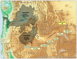
At least seven volcanic fields have been identified (Figure 2.1.1): the oldest being McDermitt (which began 16.5 million years ago), Owyhee-Humboldt (15 million years ago), Bruneau-Jarbidge (12 million years ago), Twin Falls (10.5 million years ago), Picabo (10 million years ago), Heise (6.5 million years ago), and Yellowstone (2 million years ago). Evidence for these past eruptions has been documented by careful mapping of geologic units, as well as chemical analyses and dating of volcanic deposits.
Yellowstone-style volcanic eruptions weren’t the only thing happening 17 million years ago. That time period also saw the eruption of the Columbia River Basalt—a tremendous outpouring of lava from vents in eastern Oregon and Washington and western Idaho. The lava from these vents flowed all the way to the Pacific Ocean and is responsible for some of the impressive features along the Oregon Coast, like Haystack Rock and Cape Lookout.
For many years, it was assumed that the Columbia River Basalt eruptions represented the start of the Yellowstone hotspot. The first eruptions of a hotspot would likely be voluminous, since the head of a mantle plume would be charged with heat and induce tremendous melting.
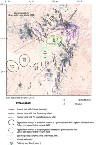
The passage of the Yellowstone hotspot also affected earthquake activity in Idaho, Montana, Wyoming, and Utah. In the late 1980s and early 1990s, geologists observed a unique pattern of seismicity around the Yellowstone hotspot track. The locations of earthquakes and fault activity forms a distinct “parabolic” pattern around the track of the Yellowstone hotspot. This “seismic parabola” is sometimes described as a bow wave forming in the wake of the hotspot. Along the seismic parabola are some of the most active faults in the region, including the Lost River fault (source of the 1983 magnitude 6.9 Borah Peak earthquake), the Hebgen fault (source of the 1959 magnitude 7.3 Hebgen Lake earthquake), the Teton fault, and the Wasatch fault. In contrast, the region inside the seismic parabola (the eastern Snake River Plain) is almost totally devoid of seismic activity.
The geologic events related to the Yellowstone hotspot drastically changed the northwestern U.S. and created the extremely unique geologic setting and the unique topographic features we know today.
Media Attributions
- Just how long has the Yellowstone Hotspot been around?
- The Yellowstone Hotspot and Columbia River Basalts
- Figure 2.1.1, USGS, Public Domain
- Figure 2.2.2, USGS, Public Domain
