Chapter 1 Introduction to Geoscience
Why Study Earth?
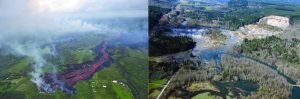
The simple answer to this question is that Earth is our home—our only home for the foreseeable future—and in order to ensure that it continues to be a great place to live, we need to understand how it works. Another answer is that geology affects your everyday life, probably more than you realize. The Earth can be a dangerous place. You might want to know if your home or apartment is at risk for damage from floods, landslides, earthquakes, or even lava flows (Figure 1.3.1).
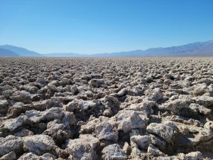
And of course, some of us can’t help but study it because it’s fascinating. Every time you step outside you can see the awesome and dynamic forces of the Earth in action. It can simply make you say “wow”, and that can often be enough to drive scientific curiosity (Figure 1.3.2). But there is more to it than that:
- We rely on Earth for valuable resources such as soil, water, metals, industrial minerals, and energy, and we need to know how to find these resources and exploit them sustainably.
- We can study rocks and the fossils they contain to understand the evolution of our environment and the life within it.
- We can learn to minimize our risks from earthquakes, volcanoes, slope failures, and damaging storms.
- We can learn how and why Earth’s climate has changed naturally in the past, and use that knowledge to understand both natural and human-caused climate change.
- We can recognize how our activities have altered the environment in many ways and the climate in increasingly serious ways, and how to avoid more severe changes in the future.
- We can use our knowledge of Earth to understand other planets in our solar system, as well as those around distant stars.
Two examples that demonstrate the importance of geological studies for minimizing risks to the public are illustrated in Figure 1.3.1. From May through August 2018, pressurization of Kīlauea’s magmatic system and ultimate caldera collapse resulted in the largest and most destructive eruption 200 years in Hawai’i (Figure 1.3.1 left). By the end of this eruptive event, an area of 35.5 square kilometers (over 8,700 acres) was covered with lava, which includes the addition of 875 acres of new land created near the eastern extent of the Island of Hawaii. Residents were displaced as lava covered over 700 structures and 48 kilometers (30 miles) of road, primarily affecting the Leilani Estates Subdivision. Much of the State of Hawaii, and areas as far as Guam, were also impacted by vog—volcanic air pollution caused by interaction of the atmosphere, with nearly 200,000 metric tons of SO2 being emitted each day of the 2018 eruptive event. These emission rates are the largest ever measured on Kīlauea, representing a total of 10 Mt (megatonnes, or millions of tonnes) of SO2.
On March 22, 2014, a large landslide covered about 40 homes and other structures as well as nearly a mile of State Route 530. It resulted in 43 fatalities in the community of Steelhead Haven near Oso, Washington, and is the deadliest landslide in U.S. history. The Oso Landslide occurred in an area of known landslide activity, but this time, the slide was much larger, traveled much further, and had greater destructive force than others previously experienced at the site. However, an incident of this magnitude was not expected based on previous studies of past events in the area as well as comparison with landslides worldwide of this height, volume and type.
Media Attributions
- Physical Geology-2nd Edition, by Steven Earle is licensed under CC BY 4.0, Modified from the original by Ryan B. Anderson.
- 2018 lower East Rift Zone Eruption and Summit Collapse, United States Geological Survey
- Revisiting the Oso Landslide, United States Geological Survey
- Figure 1.3.1 (left): Hawaiian Volcano Observatory, USGS. Public Domain.
- Figure 1.3.1 (right): Mark Reid, USGS. Public Domain.
- Figure 1.3.2: © Ryan B. Anderson. CC BY.
